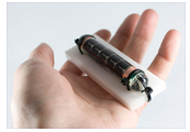
SeaTag-GEO ™ is a collection of many unique features and sensor sets itself and other location tags in amicrocosm of archival tags. SeaTag-GEO ™ is one of several label our SBIR development plan of microobservation station. Its main purpose is to obtain the geographical position. It describes the fact that animal has higher precision than that of the. For example, the averagelatitude error of our (no filtering) has been the longitudeerror of 35 nm similar.
SeaTag-GEO ™ is completely different, the cost of sensor,which based on the use of accurate, to any other filelocation. It uses the solar cell is used to download theconfiguration and retrieve log so as to reduce the cost, andmake it more reliable. Sensor 3 axis magnetometer

3 axis magnetometer
Light intensity
Temperature compensation
Temperature compensation
Power supply
Storage of solar energy (solar battery and capacitor)
Battery assisted mode optional


